Q: Who was Irvine’s Culver Road named for?
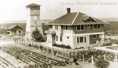
Fred Culver's impressive home at "Culver's Corner," in Irvine.
A: Hunchbacked lima bean farmer Fred M. “Humpy” Culver is immortalized on the map of Irvine. His lease on the Irvine Ranch was located on the State Highway (now the I-5 Freeway) where it intersected Trabuco Road and today’s Culver Road. “Culver’s Corner” – marked by Humpy’s home and windmill – also marked the spot where the arrow-straight highway finally made a bend, infamously sending many early automobile drivers into the ditch or worse. The name Culver’s Corner remained long after Fred’s death, at the age of 31, in 1918. Many other members of the Culver family also worked on the Ranch, including Fred’s brother, blacksmith Willard “Gimpy” Culver. Gimpy earned his nickname when he was shot in the leg serving in the posse who fought the Tomato Springs Bandit in 1912. His blacksmith shop is now Knowlwood’s restaurant on Sand Canyon Ave.
Q: Why do many of Orange County's major North/South streets have a little wiggle at Garden Grove Blvd?
A: Overlaying a flat grid (USGS township, range, sections, etc.) on a spherical surface (Earth) results in numerous places where the grid doesn't match up well. Every so often, the grid -- along which many major roads are aligned -- gets out of kilter. And that's PART of the issue here.
The larger issue though, is that each town used to be distinct, with miles of open land between each community. The roads were never intended to connect, so no thought was given to how they might connect someday. Only as the towns/cities grew to meet each other (with boundaries becoming identifiable only if there's a sign posted), did such things matter. Gradually, many of the larger streets were connected and in the 1960s there was a major effort to unify the names of these newly-joined streets. For instance, what was once Harbor Blvd., Palm Dr., Fullerton Rd, and Spadra Rd. are now all Harbor Blvd. What's now Beach Blvd is another good example of a street that once had many more names.
Garden Grove Blvd isn't the only spot with "wiggles" created by joining different streets together, but it's probably the most obvious example when looking at a map of Orange County
Q: Why is downtown Anaheim cockeyed on the map?
A: In 1859, prior to the arrival of the first colonists from Los Angeles Vinyard Society to Anaheim, the Society's surveyor, George Hansen, began preparing the land for them. After obtaining rights to an easement across Bernardo Yorba’s adjacent ranch, Hansen built an irrigation ditch which brought water down from the Santa Ana River, and then laid out the colony of Anaheim on the same angle as the ditch. To this day, the heart of Anaheim still has this cockeyed orientation. Hansen divided the land into town lots and vineyard lots – all within the boundaries of North, South, East and West streets. He also oversaw the planting of 400,000 vines, as well as some fruit trees.
[Thanks to Nick Popadiuk, Jerry Howard and Mike Martin for their questions.]
No comments:
Post a Comment
Sadly, I had to shut down comments (my favorite part of the blog) thanks to endless spam. Most of my posts are linked from my FB page, so feel free to comment there or to email me. If I can find a more secure way to do so, I will bring back normal commenting later.
Note: Only a member of this blog may post a comment.