Monday, August 26, 2019

First American in Downtown Santa Ana

Orange County Title Co., 1953 (Photo courtesy CSUF Special Collections)
Same scene in 2019. (Photo by C. Jepsen)
It's hard to think of a business that's had a broader and more sustained roll in the growth and development of Orange County than First American Corp. It’s clearly and indisputably one of Orange County's oldest and most historically significant businesses.  They've been good for O.C. and O.C. has been good for them.

Joshua D. Parker, brought his family to the town of Orange around 1872. His four boys – Millard, Josh, Charles Edward (“C.E.”), and Clarence all have interesting biographies worthy of more depth than I can give them here.

C.E. Parker started a nursery that was an early source for Orange County's walnut and citrus groves. He moved to Santa Ana in the 1880s, became a partner in a local granary, and was behind the push for Santa Ana to bring adopt the new technologies of electric street lights and telephones.
Three generations of leadership (L to R): C.E. Parker, George A. Parker, and D.P. Kennedy. (Courtesy First American)
Back in 1889, when rural Orange County split from Los Angeles, it was often still murky as to exactly how "clear" the title was on many properties. To make sure everything was legitimate, land buyers needed detailed documentation of all transactions in which their property had changed hands in the past. It was a complicated task requiring not only access to County records (including L.A. County records prior to Aug. 1889), but also Mexican land grants, U.S. land patents, and more. It also required an ability to accurately interpret legal descriptions of property that often included impermanent landmarks like trees, riverbeds and tidelines. There was a need for specialists to do this work.

Two companies sprang up to fill this need: Santa Ana Abstract Co. and the Orange County Abstract Co. In 1892, C.E. Parker bought part of Santa Ana Abstract Co. and, with his partners, merged it with their rival company in 1894.

Thus began the Orange County Title Co. (later renamed First American Title). In 1924, the company became one of the first in California to issue title insurance.
O.C. Title board and staff in 1904. L to R, standing: C.E. Parker, president; D.M. Dorman, Santa Ana businessman who with Moses Abbot built Newport Landing in 1872; Thomas L. McKeever, Santa Ana insurance executive; Frank Ey, member of pioneer Anaheim family and one-time mayor of Santa Ana; and A.J. Visel, one of the first realtors and subdividers in the county. Seated: George A. Edgar, whose Santa Ana grocery store was the informal town meeting hall; Charles A. Riggs, vice president; Frederick Stephens, secretary; Mrs. L.C. Green, title searcher; and Adelaide Cochrane, typist. (Courtesy First American)
Their central asset was their own set of property records (“abstracts”), which they’d hand-copied with great care from the records of Los Angeles and Orange counties. It took a staff of six, working six days a week, to create the highly accurate transcription that would serve as the foundation of the business. The company then compiled and indexed these records using their own system which allowed them to access the material much more efficiently than the county’s own system at the time.

“…The complete story of land titles in Orange County is told in the vast archives of the Orange County Title Company,” explained First American’s book, Orange County: Indians to Industry, in 1963. “Glimpses of the... gracious mode of life in the early days of the county may be had by perusal of the volumes in which recorded documents affecting the title to property were laboriously copied by hand. Deeds stipulating payment of the purchase price of a piece of land with tallow at $1.20 per ‘arroba’ and hides at $2.00 each often paint vivid word pictures of the county’s pioneer past. Marriage ‘contracts,’ wills and other documents offer exciting insight into the sacrifices, hopes and efforts that went into the making of the county.”
This was O.C. Title's third location in Downtown Santa Ana (circa 1900). The 1931 building now sits on this and surrounding properties. (Courtesy First American)
Parker remained president from 1889 until his death in 1930, after which the company continued to be steered by his family. First his son George A. Parker took over as president. Then C.E.'s grandson, Donald Parker Kennedy, became president, expanding the company's reach beyond Orange County in the late 1950s and changing their name in 1960 to First American Title Insurance. Don’s son, Parker S. Kennedy, would later take over.

George’s son, attorney Ted Parker, began collecting photos of early Orange County from the scrapbooks of pioneer families, from the studios of photographer Ed Cochems, and from anywhere else he could find them. Today, the First American Historical Collection includes over 12,500 images – many of them iconic.
Architectural rendering from the Los Angeles Times, Jan. 19, 1930.
For many decades, the O.C. Title/First American headquarters was a beautiful art deco building, with cast stone columns at the southeast corner of Main St. and 5th in Santa Ana.

"Allen Ruoff, Los Angeles and Santa Ana architect, is preparing plans for a two-story brick and concrete office and archives vault building at the southeast corner of Fifth and Main streets, Santa Ana” announced the Los Angeles Times on Jan. 19, 1930. “...Ruoff has [also] just completed plans for a $250,000 mausoleum, chapel and crematory to be built at Santa Ana for Fairhaven Cemetery."
O.C. Title Co., 1930s. Color adjusted for emphasis. (Photo courtesy Mark Hall-Patton.)
O.C. Title Co. building, 2019. (Photo by Chris Jepsen)
Contractor P.J. Walker Co. of Los Angeles began construction on the headquarters in July 1930 and finished in early February 1931. It was built in such a way that additional stories could be added later, should there be a need.

Indeed, there was a need. But rather than building upward, First American spread out. They began in 1954 by adding a new wing featuring a modern/Jeffersonian neo-classical façade by architect Thomas F. Shoemaker. This was followed by a larger expansion in 1967 that filled the entire block and also re-clad much of their 1931 art deco building to match the neo-classical look. Some additional renovations occurred in 1977. But the original façade is probably still sitting underneath all the “frosting” even today.
The First American complex circa 1963 – between the 1954 and 1967 expansions.
A little birdie in a window tells me that the farthest wing of the complex – at 4th and Bush streets – may have been modified into a J.C. Penney department store in 1949 (rather than entirely rebuilt as advertised) from part of an earlier historic building. In 1976, the Penney's was re-reclad neo-classical style and became First American's east wing. If part of the older 1890s facade facing 4th Street still hides under all that (see photo below) falderal, then it has its own interesting pre-Penney's story to tell -- as a tin and hardware store downstairs and the public library and public hall upstairs. Could there be remnants of this old façade beneath the First American cladding? It would be fascinating to know.
E. 4th St. at Bush St., looking west, circa 1910. Image color adjusted for emphasis. (Courtesy Tom Pulley)
E. Fourth St. at Bush St., looking west, 2019. (Photo by Chris Jepsen)

In any case, the campus served First American well for decades. But the entire complex was largely abandoned when First American moved into their new corporate headquarters at MacArthur Blvd. and the 55 Freeway around 2000.  (They were determined to stay in Santa Ana, even if they had to go to the outskirts to find a parcel large enough.)
Around the same time, the company was renamed again to become the First American Corporation, reflecting the wider array of financial, insurance, data services and other business services they provided. In 2010, the enormous (and by now international) company was split into First American Financial Corp. and CoreLogic Inc. The latter encompassed the property information and analytics aspects of their business. In 2017, First American's total revenue was $5.8 billion. 
Planned new development by Toll Brothers. (Courtesy City of Santa Ana)
Recently, the old O.C. Title/First American block was purchased by Toll Brothers, who plan to build a large mixed-use development on the site. Few would refute the idea that this long-empty block needs some redevelopment -- preferably into something iconic, unforgettable, and worthy of anchoring the heart of the heart of the heart of our county seat. It would be the perfect crossroads for an architect to celebrate our past while also pointing Santa Ana toward a brighter future.

Check out the project page on the City's website, with particular attention to the Cultural Resources section of the Environmental Impact Report Technical Appendices and share your thoughts.

Monday, August 19, 2019

La Matanza

A vaquero at work in 1830s California.
Q: Where did La Matanza St. in San Juan Capistrano get its name? Doesn’t it mean slaughter or massacre?

From the 1820s to the 1860s – when our local economy was still based on cattle – the matanza was the annual time, from July through September, when steers that had reached the age of three were slaughtered with long sharp knives for their hides and tallow. (Cows were generally spared, for breeding.)

Vaqueros called navajadores began by going out on horseback in threes and finding the steers. Hundreds or even thousands might ultimately be slaughtered. In the Mission era, the steers were herded to a specific flat open spot – also called la matanza – a good distance from the mission or pueblo, where the slaughter process would be more orderly and less wasteful. (After secularization, the navajadores were sometimes more prone to just slaughter the steers where they found them, take the valuable hides, and leave the bodies to rot.)

Once the cattle were dead, peladores would remove the hides. Then, tasajoras (butchers) would gather the fat for tallow and cut any meat that was to be saved. Waste material was often burned afterward. (There really wasn't a large market for beef here until the Gold Rush hit in 1849.)

Like any agricultural harvest, the coming of the matanza was cause for celebration. Fiestas were held (presumably with a lot of beef on the menu), new dresses were debuted, and so forth.

The first references I see to La Matanza Street in San Juan Capistrano are around 1939, which is not a surprise. (See my article on Verdugo St.) I’m not sure whether the actual matanza location for the San Juan mission has any relationship to the street with that name.

Thursday, August 08, 2019

Verdugo Street, San Juan Capistrano

Horse tied at Verdugo St. near the Swallows Inn on Camino Capistrano, circa 1960.
Often what begins as a seemingly minor question turns into a larger and more interesting project than I expected. Isobel D. wrote, “What is the origin behind the name of Verdugo Street in Capistrano?”
 
For the little town of San Juan Capistrano, the 1930s were a period of renewed interest in local history. They began to realize that their best shot at economic survival during the Depression was we now call "heritage tourism." Accordingly, they played the "romance of the Mission Era" theme to the hilt. Their efforts spanned from architectural preservation to Mexican fiestas. They also renamed many streets.
 
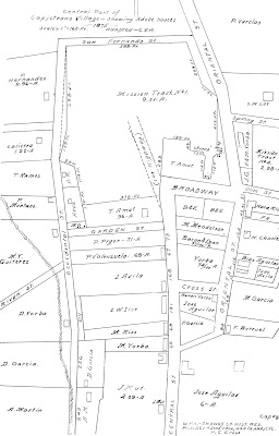
Colorful raconteur, self-promoter and history buff Alfonso Yorba (a.k.a. Chauncey Chalmers; a.k.a. Bruce Conde; a.k.a. Hajji Abdurrahman; a.k.a. Major-General Bruce Alfonso de Bourbon; a.k.a. His Serene Highness Abdurrahman Bruce-Alfonso de Bourbon, Prince of Conde. Real name: Bruce Hamilton Chalmers) led the drive to change the English street names into Spanish ones. As historian Pam Hallan-Gibson writes, "McKinley became Del Obispo, Garden became Verdugo, and Oriental Street returned to [being] El Camino Real. Occidental Street became Los Rios Street and Central was changed to Camino Capistrano. Most of the new names had historical significance." 
Map of San Juan Capistrano in 1875, from the 1936 WPA report, “The Adobes of Orange County California.” Note the street names.
So what was the source for the street name Verdugo? Thanks to San Juan Capistrano Historical Society Museum Curator Jan Siegel, we now know. She found something written by Alfonso Yorba that's pretty specific:
 
"[The] last of the streets leading into the old ex-plaza is Verdugo Street," wrote Yorba, "extending west from near the northwest corner of the pueblo square, and indicting the approximate location of the "L" shaped adobe of Don Pedro Verdugo in pueblo days. The high-walled adobe once stood on the ground now occupied by the Hotel Capistrano and the Mission Theater [now Hennessey's]. Fred Stoffel, builder and owner of the hotel, remembers the old adobe... Good old Monsignor St. John O'Sullivan, beloved restorer of the mission, was heartily against [the demolition of the Verdugo Adobe] and even went so far as to take the occasion of a sermon in the  mission chapel to warn devout San Juanenos 'to lay off helping Mr. Stoffel tear down the historic landmark.' So energetic was the zealous prelate in his fight to save the adobe that Fred had to do the work himself."
Pedro Verdugo, in the ruins of Mission San Juan Capistrano, circa 1890s. (Courtesy USC Libraries Special Collections)
Pedro Nolasco Antonio Jose Verdugo was the longtime sextion at the mission -- maintaining the buildings and grounds. The child of Julio and Maria Verdugo, he'd been baptized in 1820 at Mission San Fernando; married Gertrudis Gonzales sometime after 1844, and died in Capistrano in early 1899.

Pedro was the grandson of Jose Maria Verdugo, for whom many Southern California landmarks are still named. In California Place Names, Erwin  G. Gudde writes that the Verdugo name's appearance in Los Angeles County "commemorates the Verdugo family. Jose Maria Verdugo, a  corporal of the San Diego company, who had served in the mission guard at San Gabriel, was grantee of one of the first land grants, dated October 20, 1784 and January 12, 1798. The name Rancho de los Verdugos is repeatedly mentioned in documents and appears in Narváez’ Plano of 1830 as Berdugo. The modern town [of Verdugo City -- now part of Glendale] was laid out by Harry Fowler in 1925, but Verdugo Park is shown on the maps of the 1910s as the terminal of a local railroad. The mountains are shown as Sierra de los Berdugos on the diseño of La Cañada grant (1843); and Sierra or Cañada de los Verdugos was the name of an unconfirmed grant of 1846.”

Jose Maria Verdugo and his brother Mariano de la Luz Verdugo were among the first to come to Alta California in 1769, marching north to San Diego with Fernando Rivera y Moncada on the first leg of the Portola Expedition. (In retirement, Mariano would serve as Alcalde of the Pueblo of Los Angeles.) Their father, Juan Diego Verdugo (1715-1780) had also been a soldier and served at Loreto and various missions in Baja California until the mid-1770s.

During the Mission and Rancho eras, the Verdugos spread out across Baja and Alta California and seemingly intermarried with every other family in early Southern California.

Local on the map named for this large Californio family include Verdugo Canyon, near San Juan Capistrano and south of San Juan Hot Springs.

In Los Angeles County, there's a Verdugo Street, the (late 1920s) Verdugo Woodlands tract and the Verdugo Hills in the Glendale area. There's also a Verdugo Wash and the Verdugo Mountains near La Cañada.
A Spanish soldier on the California frontier.
Pedro was not the only Verdugo to end up in San Juan Capistrano. One of the first Verdugos to leave their mark on the town was another of Don Juan’s sons, Juan Maria Verdugo, a Spanish soldier who served as "Cabo" in Capistrano from at least 1797 until at least 1802.

Later came one of Juan Maria’s nephews, Miguel Verdugo. According to the Orange County California Genealogical Society's book, Saddleback Ancestors, "By 1836,...Miguel was living on the Rancho Santa Ana Abajo [northwest Orange] and later served as mayordomo there for Jose Antonio Yorba, the younger. In 1841 he was granted a house lot in Pueblo San Juan Capistrano..."
According to Capistrano historian Jerry Nieblas, Miguel Verdugo’s adobe home was near the Plaza, not far from the Blas-Aguilar adobe. This matches up well with other historians' descriptions of Miguel’s home being on the east side of El Camino Real, south of the Ortega Highway.

The Verdugos "were well liked for their local generosity and were somewhat influential during their years here,” said Nieblas, citing an oral history of his grandmother, Buena Ventura Yorba Garcia Nieblas, who in turn heard stories of the Verdugos from her parents, Felipe Yorba Garcia and Florencia Yorba Sanchez-Colima Garcia.

It’s unknown how long Miguel stayed in town, as he also had a home in Los Angeles. But it’s known that in 1857 he was across the road at Mission San Juan Capistrano visiting his friend and neighbor Juan Forster at the moment the Flores gang raided the town.

Pedro Verdugo -- namesake of the street -- was also mentioned among the witnesses to the Flores raid.

Thursday, August 01, 2019

Happy 130th birthday, Orange County!

How do we cut this cake into 3.18 million slices?
The recorded history of what’s now Orange County dates back to 1769 (we just celebrated the 250th anniversary of Portola’s arrival here last week), and this land was home to Indian people for many thousands of years prior to that. But Orange County itself is a more recent invention.

On August 1, 1889, the southern portion of Los Angeles County (itself founded in 1850) broke away to become Orange County. On the day we separated, we had about 15,000 residents, three incorporated cities, and no paved roads.

Map from the year of Orange County's birth. (Courtesy Orange County Archives)
Our struggle to separate from L.A. began in 1870 with Anaheim mayor Max Strobel’s proposal for “Anaheim County.” It would be the first of many attempts to separate from L.A. over the next nineteen years. We had the traditional American desire for self-determination. We thought our taxes were mostly going to the “big city” and that our voices weren’t being heard. And we were certainly tired of interminable treks up the unpaved El Camino Real to conduct government business in Los Angeles. We no longer wanted or needed to be L.A.’s “red-headed step child.”

Generally, Sacramento shot down our separation bills because the new state constitution had no provision for creating new counties. This let opponents claim that creating a new county was unconstitutional. This, in turn, made our fight for succession the bellwether for determining if new counties could be formed anywhere. If we succeeded, many other regions of the state would follow.
O.C. Supervisors Don Wagner and Lisa Bartlett sign a birthday card, while Supervisor Michelle Steele looks on.
Various bills drew our proposed physical border at different points, from Coyote Creek to the Rio Hondo. Anaheim supported bills that drew the line farther north, making them the center and logical seat of the new county. Santa Ana supported the bills that drew the line farther south, for the same reasons. And each opposed the bills supported by the other. The two towns developed a heated rivalry.

The name Orange County was first proposed in 1872, before we had any commercial citrus. Oranges were still a rarity and were associated with sunny Spain and a coastal Mediterranean climate. The name was simply a ploy to draw people here.
Lisa Bartlett, Chair of the Board of Supervisors, MCed a small, brief 130th birthday remembrance before this week's meeting.
By the late 1880s our booming economy -- spurred largely by the arrival of the railroads – finally set the stage for our liberation. We finally had enough money and power to do some arm-twisting.

Leading local Democrats and Republicans finally joined forces for a serious lobbying effort, and with the support of San Francisco – which, even then, encouraged “sticking it” to Los Angeles – a bill was finally passed allowing a vote to create a new county. Anaheim was unhappy that the border was drawn a Coyote Creek. But the public still ratified the bill in the June election. On August 1st we became a separate county. On August 5th the Board of Supervisors met for the first time, organizing our county's government.
Today, we have 34 incorporated cities and a population of 3.18 million - a more than 22,000% increase since our founding. Sorry, L.A.,… You can’t have us back.